
Wind and thunderstorm warnings issued
An unseasonably deep area of low pressure will bring strong winds and heavy rain to the UK on Wednesday.
A Yellow National Severe Weather Warning for Wind has been issued for southern parts of England on Wednesday, running from 04:00-18:00. Gusts are likely to reach 50mph in some English Channel coastal areas with 55 to 60mph possible in the most exposed locations in the far southwest and, perhaps, a little higher in the very most exposed parts of coastal southern England such as the Needles.
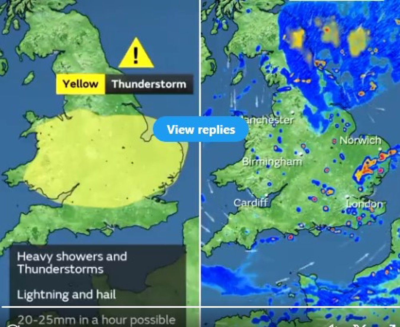
Along with the strong winds, the system will being some heavy rain. A Yellow severe weather warning for thunderstorms has been issued covering a large area of central England and Wales. Within this area slow moving thunderstorms could lead to rainfall accumulations of 20-25mm within an hour. Some locations could see in excess of 40mm in a 2-3 hour period.
Met Office Chief Meteorologist, Dan Suri, said: “An unseasonably deep area of low pressure for the time of year will move into Ireland during the early hours of Wednesday then continue across Wales and England during Wednesday daytime. Heavy rain associated with this low will affect large parts of the UK tonight and on Wednesday, some of the heaviest rain occurring on Wednesday over central parts of England and Wales where some locations could see 40mm of rain in just a few hours from thundery downpours. This deep low will also bring high winds into the UK on Wednesday, especially the south. Gusts of up to 60mph are possible in the very far southwest early on Wednesday whilst further along the south coast the highest gusts will be during Wednesday daytime.
“Despite the centre of the low pressure crossing the UK, the highest wind speeds will be further south over northern France and the Channel Islands. The low will pull away eastwards from the UK during Wednesday evening and night, leaving a calmer day on Thursday though some heavy showers could persist in the east.”
Highest winds further south
Unlike tropical cyclones, mid-latitude low pressure systems that affect the UK see their winds distributed both less symmetrically around the low centre and extending further away from the low centre. This means that the strongest winds and greatest impacts can be further away from the low centre than in tropical cyclone. So, although on Wednesday the low centre is crossing the UK, the strongest winds are further to the south over northern France and the Channel Islands.
Holiday season
With many holidaymakers making trips accross the UK, Rod Dennis, a spokesperson for RAC, provides some advice for staying safe on the roads: "The distinctly autumnal feel to this summer continues this week, with yet more heavy rain and strong winds making driving conditions challenging. Drivers attempting to drive through patches of standing water risk losing control, so the best course of action is to slow down and carefully avoid them whenever possible. As the wind will be especially strong along southern coasts, drivers towing caravans will need to be cautious while those carrying items on the roof should make sure these are properly secured.”
Further ahead
Looking ahead to the rest of August, there are some early signals for at least a brief spell of something a little warmer and more settled to develop towards the end of next week, most likely for southern areas. However, it remains that the greatest chance of seeing anything more widely settled would be through the second part of August, although this may be accompanied by an increasing risk of thundery showers. With unsettled conditions never too far away, it looks unlikely that we will see any prolonged or excessive heat, with the chance of heatwaves here in the UK being lower than some recent Augusts.