
Council propose to block off Roads and Streets in Southport to create "Liveable Neighbourhood's"
Sefton Council are proposing to block off at least thirteen Roads and Streets in Southport to create what they call a Liveable Neighbourhood.
The affected area is the Roads and Streets surrounded by Eastbank Street,Scarisbrick New Road,Ash Street,Cemetery Road,Upper Aughton Road,Aughton Road, Lord Street West and Lord Street.
The idea is to force vehicles off residential streets and onto A and B roads.
Everyone will still be able to get to any address in the area in a car or other vehicle, but they may have to travel slightly further than before.
According to the Council "Liveable Neighbourhoods reduce pollution by taking away the traffic which use the streets as a cut through."
The Council have done a letter drop and online survey only 14% of people responded.
Design Feedback Drop-In Event
Anytime between 3.30pm – 7.30pm on Tuesday 19th October at the Salvation Army Building
65 Shakespeare St, Southport, PR8 5AJ
Have your say click below
https://sustrans.onlinesurveys.ac.uk/southport-designs-feedback
Below are maps of the proposed plans.
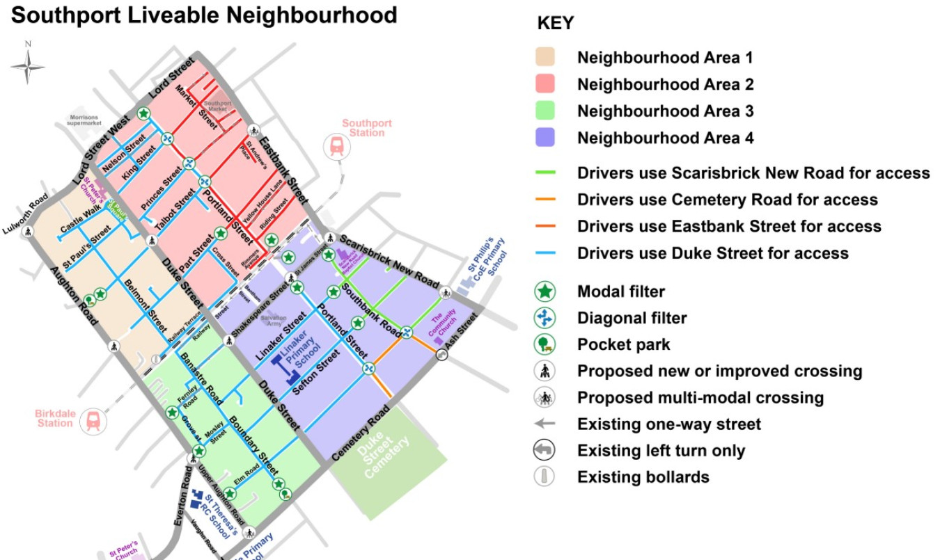
A1 - Proposed crossing and/ or junction narrowing at the junction between Aughton Road and Lulworth Road
A2 - Proposed crossing at the junction between Talbot Street and Duke Street
A3 - Proposed pocket park and modal filter at the junction between Hollybrook Road and Aughton Road
A4 - Proposed crossing over Aughton Road between York Road and York Avenue
Location 1 - Pocket park at Hollybrook Road and Aughton Road
Bollards are added, alongside some planting to stop traffic cutting through the neighbourhood. Vehicles may use Hollybrook Road to access Shakespeare Street or the town centre and avoid congested junctions and traffic lights, such as the Lord Street junction, the Duke Street / Lord Street junction and the Portland Street / Lord Street junction. Hollybrook Road is a residential street and not designed to accommodate high volumes of traffic.
Residents on Hollybrook Road will still be able to access all driveways by vehicle, and travel for cyclists and walkers would become safer and easier with the addition of the proposed filter.
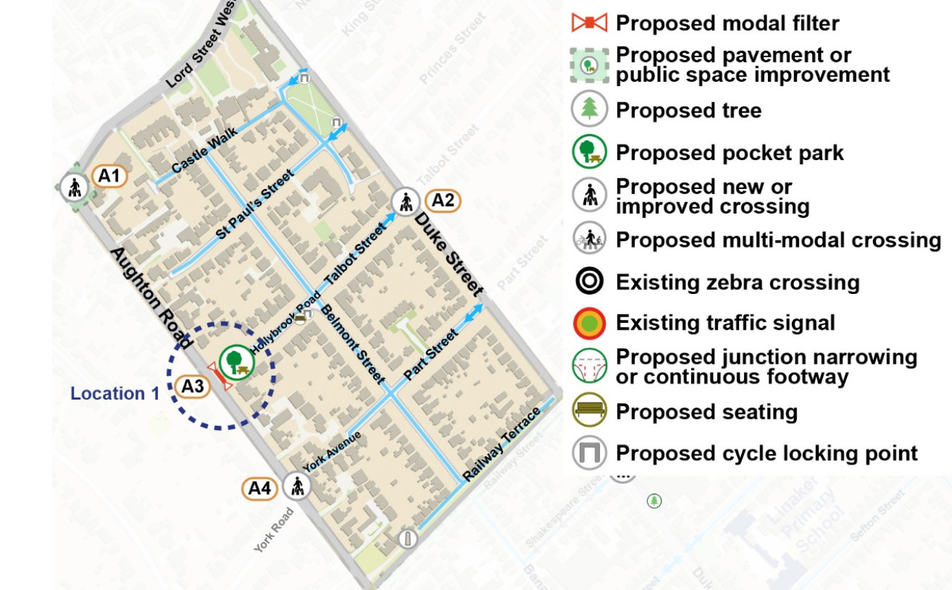
B1 - Proposed modal filter and public space improvements at the junction between Portland Street and Lord Street
B2 - Proposed diagonal filter between King Street and Portland Street
B3 - Proposed multi-modal crossing over Eastbank Street
B4 - Proposed diagonal filter between Princes Street and Portland Street
B5 - Proposed diagonal filter between Talbot Street and Portland Street
B6 - Proposed modal filter at Part Street
B7 - Proposed modal filters either side of the railway crossing on Portland Street
Location 2 - Modal filter at junction of Portland Street and Lord Street
Restricting vehicular traffic down Portland Street frees up road space in front of the Gusto restaurant to create a pleasant, less-trafficked area for use as an outdoor dining space and/or dedicated restaurant car parking area.
An outdoor dining space could also give more presence to the Gusto restaurant on the busy Lord Street thoroughfare, and potentially attract more customers into the business.
Those using the buildings next door to Gusto and restaurant staff and customers will still be able to fully access their properties and businesses by vehicle should a modal filter be installed. Deliveries, loading and refuge vehicles will still be able to provide service to all the buildings.
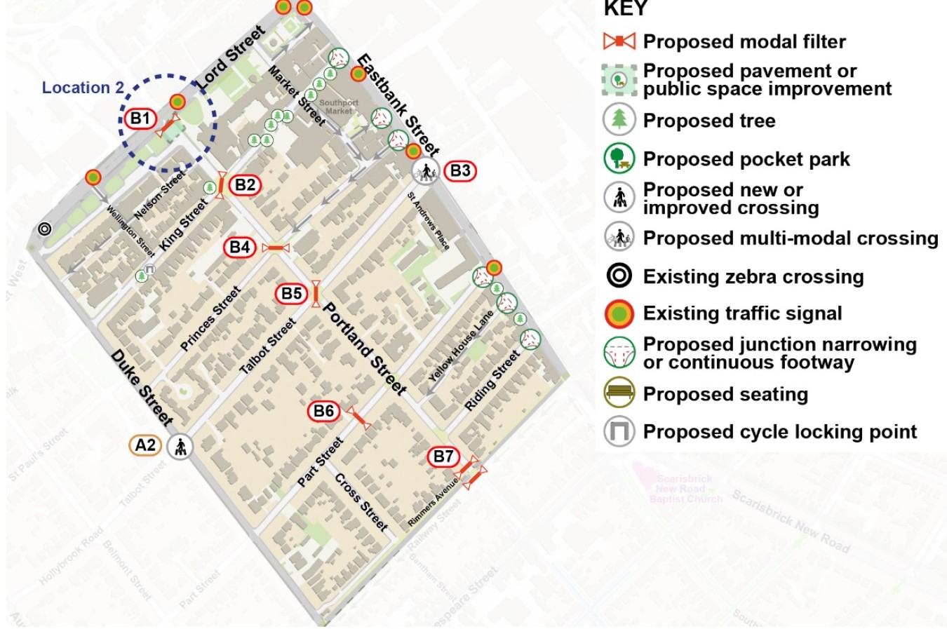
C1 - Proposed crossing at the roundabout next to St James Street and Southbank Road
C2 - Proposed modal filter at the junction between Southbank Road and St James Street
C3 - Proposed enhancement of Railway Street & The Walk to create a safe active travel corridor
C4 - Proposed crossing and public space improvements at the junction between Shakespeare Street and Portland Street
C5 - Proposed modal filter on Portland Street near to Shakespeare Street
C6 - Proposed modal filter on Linaker Street
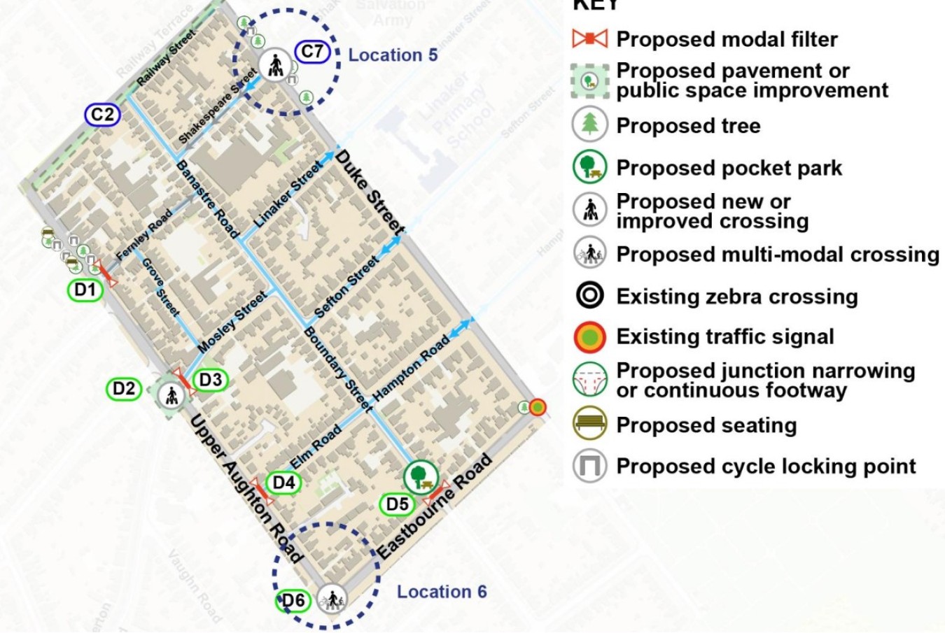
C7 - Proposed multi-modal crossing at the junction between Hampton Road and Scarisbrick New Road
C8 - Proposed crossing at the junction between Shakespeare Street and Duke Street
C9 - Proposed modal filter on Sefton Street
C10 - Proposed diagonal filter between Southbank Road and Hampton Road
C11 - Proposed diagonal filter between Portland Street and Hampton Road
Location 3 - Modal filter and public space improvements at Portland Street and Shakespeare Street
The consultation comments & traffic data indicated speeding cars and congestion are problematic here due to both rat running and traffic queuing up waiting for the level crossing to open.
The bollards proposed would reduce the build-up of through traffic travelling along Portland Street/ James Street into the town centre, and remove some traffic from around the convenience store; making it safer to access. Seating and greenery have been proposed to improve the setting and provide seating for those using the area.
Location 4 - Diagonal filter at Portland Street and Hampton Road
A diagonal filter is proposed to prevent through traffic from driving along Portland Street & Lord Street to avoid Scarisbrick New Road and Southbank Road.
The Tell Us About Your Street survey also revealed some crime incidents in the area, so extra lighting is proposed to make the area safer at night.
D1 - Proposed modal filter at the junction between Fernley Road and Upper Aughton Road
D2 - Proposed new crossing and changes to the mini-roundabout to calm traffic on Upper Aughton Road
D3 - Proposed modal filter at the junction between Mosley Street and Upper Aughton Road
D4 - Proposed modal filter at the junction between Elm Road and Upper Aughton Road
D5 - Proposed pocket park and modal filter at the junction between Boundary Street and Eastbourne Road
D6 - Proposed multi-modal crossing at the junction between Upper Aughton Road and Eastbourne Road
Crossing at junction of Duke Street and Shakespeare Street
Concept 1 - Both the traffic monitoring and your comments indicated that speeding traffic moves along Duke Street, creating a busy and dangerous road that is crossed by children on their way to Linaker Primary School. To make the route to school safer for all, an informal street art crossing is proposed to traffic calm, as well as 20mph signs to remind those in vehicles to travel within the speed limit. People also requested in the Tell Us About Your Street Survey and the workshops ‘greening’ (plants and flowers), better lighting & changes to the parking layout to reduce the number of vehicles backing into the road; all of which are shown in the sketch proposal. Bollards are proposed along the footway kerb lines near parking bays and on junction corners to stop vehicles from obstructing footways. Bee-friendly plants and a tree are added to improve place quality, and lighting so people are more visible crossing the road at night.
Concept 2 - Concept 2 shows a formal zebra crossing instead of a street art crossing, proposed to create a safe, protected road corridor for children travelling by foot or wheels to school, as well as others.
Location 6 - Pocket park at junction of Boundary Street and Cemetery Road
Benches, bollards, trees and street art have been added here to prevent rat-running traffic along Boundary Street that could be avoiding congestion on Cemetery Road and Scarisbrick New Road. Benches, bins and lighting are also proposed in line with comments received via the surveys and workshops.
https://sln-sustrans-uk.hub.arcgis.com/